Visiting : Humevale, Kinglake NP, Break O Day, Yea Spur
Distance : ~195km
When : Sunday 17th October, 7am @ Fed Square
Where : Click here for route map
This is a nice tour of the hills between Kinglake and Yea. We'll start off with the Humevale climb and then bomb down through Kinglake National Park before hitting Break O Day Road. Then it's up Junction Hill and out onto Yea Spur - should be great views from up there. On the way back we'll go back roads down to Kinglake NP again and climb up a different way than we came down. Then it's up to how we feel - Hildebrand/Mine down to Hurstbridge? Keep going to the city or bail out on the train?
Lots of km's in this one and we should see some beautiful country hidden away off the main roads.
The full story
Well that one had a lot more cow poo than usual.
Up to Pheasant Creek
Weather was great for riding when we set out - cool and cloudy. It stayed like that all day with the occasional sunny break and the odd misty rain shower. I carried my gillet around all day for nothing - bah!
The four of us chatted our way up Plenty Road and ogled Jeremy's new ride. This was its first proper outing - hell of a way to christen it.
Ridge Road was the first dirt of the day and rad as usual. Humevale Road was the first climb of the day and we chatted and spun our way up and on to Pheasant Creek Bakery for a feed. We were about 70km in already but, in my mind, the ride was just beginning. We fueled up, filled our bidons and camelbaks and headed off down through some awesome foresty roads before hitting Kinglake National Park proper.
Captains Creek Road
We took Captains Creek Road down through the national park and it was wicked. Pretty much all downhill on gnarly 4wd terrain. Road was nice and wide but badly rutted and eroded in places. There were plenty of clay sections that were slick and slippery and off camber. Definitely had to keep your wits about you if you didn't want to slip off and end up on your back. This would be a great road to include in a ride from/to Hurstbridge Station if you wanted to see some quality terrain without taking all day.
So, we came out the other side and found our way to Melba Highway for a few kays before ducking onto Break O Day Road. No water or food for the next 50-60kms. (i really need to make sure I post more warning about long sections without water)
Gimme a break
Break O Day Road was pretty drab. We were all into the mid-point of ride where the enthusiasm of the morning dips a little, you're starting to feel the ride in your legs and you're faced with 12km of headwind on a moderately trafficked boring road (boring compared to the bomb down through the national park anyway). We just ground out the kays silently and eventually hit Whittlesea-Yea Road where we had a nice sit-down and fed our faces.
About a hundred kays in at this point and we were at the base of Junction Hill - the second climb of the day. Spirits were a little low but I tried to perk everyone up by reminding them (and myself) that we were just about to get to the fun bit! Yea Spur is what we came to see and spurs means climbs. So, off we went up the hill.
Up to the spur
Honestly it was a lot easier than I remembered. I'd only ever ridden around these parts on ~70" fixed so hitting the same hills with ~54" and a freewheel was luxury! Which is not to say it was easy - we were all sweating when we finally crested Junction Hill and found our little turn-off onto Yea Spur Road. Which was the beginning of the aforementioned fun bit.
Awesome views from up there - we rode right out along the spur and the further we went, the further out into the distance we could see. Down towards Yea - the line of hills on the horizon near Ghin Ghin where my father-in-law goes fishing, back over the other way to Mt Disappointment and around the other way again to the alps way in the distance past Eildon.
I thought the spur road was going to be pretty flat but it turns out it was a real rollercoaster of short sharp dips. There was lots of grunting, swearing and a little walking at this point but we soldiered on towards a trig point up on the hill in the distance. I love trig points - they're irresistible.
Busted!
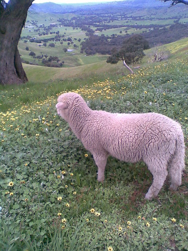
We rolled through an open gate and on up the hill but we barely got 50 metres before something came bolting out from behind a tree and rushed HMC. A sheep! What the hell?! We all stopped and it happily ran around to each of us and sniffed our bikes and asked for pats. We figured the little rascal must have been a pet - it looked clean, shorn not so long ago and hadn't had its tail docked. The owners must have left the tail on so it could pretend it was a dog. It followed us up the hill a ways and we hiked up the last part to the trig point.
Awesome views from up there. Trig points are designed to be seen for miles around so they always command great views. We chilled for a bit and then started heading down. Bit of trail confusion around here because the roads were unnamed but google got us through. We switchbacked our way down from the spur and soon we were down in the valley looking back up at where we just were. I wonder if the sheepy was looking down at us?
Down in the valley
The cockies in the valley were all screeching out at each other "Bikes! Bikes! Hey there's frickin' bikes!" and the cows along the fenceline ran away and scared their friends as we rolled by. Easy riding now and we were back on well signed roads. Nik and HMC were getting low on water though and we started considering bailout options that would take us to somewhere we could fill up. We worked out an alternative route - all on well-marked roads - and off we went up the road next to Ti Tree Creek.
And then we were in the middle of someone's farm.
Fubar
The road disappeared and we arsed around for ages checking google maps and then backtracking and trying to reconcile google's reality - the relatively major looking Ti Tree Creek Road - with what we saw all around us, which was paddocks full of angry cows crisscrossed by barely discernible ute tracks that all led to fences, gates, wide irrigation channels and mud, lots of green mud.
We finally got through to where we had to be but it was a debacle getting there. Jeremy and I shared around water from our camelbaks but now we were both out too. We were covered in mud and crap, Jeremy's chain snapped, the herd of cows whose home paddock we were riding through were making a hell of a racket that was echoing through the whole valley and I was just waiting for a ute to come flying around the corner with an angry farmer wondering what the hell was happening to his stock.
Knee deep
I was pinning all my hopes on moving forward - we had to find Margett's Road. The alternative was to backtrack all the way back to Whittlesea-Yea Road and then climb up the other side of Junction Hill which unlike the side we'd climbed earlier, was about 7-8% and, speaking for myself, would have done me serious mental harm - turning back would have felt like a failure and finding Margett's Road would have felt like a victory after all that cow-bound chaos and god knows our morale needed a boost. I was feeling bad that I'd got us into such a pastoral situation - I mean, something always goes wrong on these rides but just not usually so spectacularly. To their credit, the guys all soldiered on and, if they were feeling low, they did a good job of hiding it and just getting on with the task at hand. Especially HMC. We were all hiking it up a steep rocky track out of the cow paddocks and he was bringing up the rear and calling out gradient readings from his new garmin "21%! ... 24%!!!" and then the next thing I know he's got back on the bike and is overtaking me, bent over double and cranking it up the hill. Dude, wtf?!
Often on these rides there are "No through road" signs but they usually mean, like, no family cars because it turns into 4wd terrain or it goes into a national park walking track or something. Either way, it's still fine for bikes. But not this time. I can now categorically say that, despite what both google maps and street-directory.com.au say (i always double-check questionable sections before the ride) - that Ti Tree Creek Road is very much a 100%, for realsies, No Through Road.
Break on through
So, eventually we hiked and climbed and jumped and cranked our way up to Margett's Road and pretty soon we hooked up with Whittlesea-Yea Road right on top of Junction Hill. Which we proceeded to bomb all the way down to Flowerdale. We were all parched by now so we raided the primary school and drank our fill from the bubblers. At last! HMC had said earlier that he felt like he had the legs to keep going on the original route but his water wouldn't last - it was a wise move to back off and seek an alternative route. It doesn't matter how good your legs are feeling, if you run out of water it's only a matter of time before you crash hard. On this day, I'd say we got to those primary school bubblers just in time - no harsh words were said and we all perked up as we filled our bidons and shared around our remaining food.
We rolled on to Hazeldene (past the Flowerdale Hotel where I could quite happily have stopped in for a pint or three) and luckily the shop was still open. We stumbled around and grabbed chips, lollies, Big Ms and whatnot and pulled up some chairs outside to refuel for real and plan our next move.
The end
Light was running out and, though we were energised by the food and drink (and general confidence of having an actual road to follow) we were all pretty beat and after doing the maths Jeremy and I called in for evac. Plan was to finish our food and then start riding up to Kinglake West and get picked up along the way wherever our paths crossed. We started rolling out of Hazeldene and made pretty good time actually - a belly full of mixed lollies can do wonders. We reached the 70km/h sign which signals the start of the climb up to Kinglake West and still no sign of either of our lifts. On we went, grinding up the hill, fully at the business end of the ride, just getting it done - a top effort all round. We paused at the top of the climb just before Kinglake West and HMC said that his garmin machine reckoned we'd done 2500m of climbing for the day.
It felt like it.
No sooner had we started rolling again when my ride turned up and I made hasty goodbyes before chucking my bike on the roof and heading back home just in time to give Max a feed and put him to bed.
Thanks Nik, HMC and Jeremy for making it an awesome ride. This one could have turned a lot darker than it did so thanks for being cool even when we were knee deep in cow dung with no water and no road to follow. To paraphrase Val Kilmer, "You can be my wingmen any time!"
>> Click here for more photos <<
No comments:
Post a Comment
Note: Only a member of this blog may post a comment.